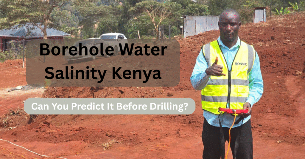
The 500,000 Shilling Question Every Kenyan Property Owner Asks
Borehole water salinity Kenya is one of the most critical concerns for property owners investing in water drilling projects. You’ve saved diligently, purchased your land, and you’re ready to drill your borehole. Then a nagging question keeps you awake at night: “What if the water is too salty to use?”
This isn’t an irrational fear. Every year, thousands of Kenyan property owners invest between KES 500,000 to KES 2,000,000 drilling boreholes, only to discover the water is too saline for drinking, cooking, or even bathing. Understanding borehole water salinity Kenya patterns could be the difference between a successful project and a devastating financial loss.
At Bonvic Drilling Company, we’ve worked across multiple counties in Kenya, and we’ve seen firsthand the heartbreak of property owners pumping unusable water from expensive boreholes. The good news? In most cases, water salinity can be predicted with reasonable accuracy before you drill a single meter.
In this comprehensive guide, we’ll reveal the professional methods geologists and drilling experts use to assess salinity risk, explain which Kenyan regions are most vulnerable, and show you how to protect your investment.
Understanding Water Salinity: What Every Kenyan Property Owner Should Know
What is Water Salinity?
Water salinity refers to the concentration of dissolved salts and minerals in water, measured as Total Dissolved Solids (TDS) in milligrams per liter (mg/L) or parts per million (ppm).
WHO Water Quality Standards:
- 0-500 mg/L: Excellent drinking water
- 500-1,000 mg/L: Good quality, acceptable for drinking
- 1,000-1,500 mg/L: Fair quality, noticeable taste
- 1,500-3,000 mg/L: Poor quality, not recommended for drinking
- Above 3,000 mg/L: Brackish water, unsuitable for most uses
Common Salts Found in Kenyan Borehole Water
- Sodium Chloride (NaCl) – Common salt, prevalent in coastal areas
- Calcium and Magnesium Salts – Cause water hardness
- Sulfates – Found in volcanic regions
- Carbonates and Bicarbonates – Create alkaline water, common in Rift Valley
- Nitrates – Often from agricultural contamination
Why is Salinity a Problem?
Highly saline water poses several challenges:
✗ Health risks: Excessive sodium intake, digestive issues
✗ Unpleasant taste: Bitter or salty flavor makes water undrinkable
✗ Equipment damage: Corrodes pipes, pumps, and appliances
✗ Agricultural impact: Damages crops and reduces soil productivity
✗ High treatment costs: Reverse osmosis systems cost KES 150,000-500,000
The reality is simple: a salty borehole can render your entire investment worthless unless you’re willing to spend significantly more on treatment systems.
Can You Really Predict Borehole Water Salinity Kenya Before Drilling?
Short answer: Yes, but with important caveats.
Through scientific investigation, we can predict water salinity with 70-85% accuracy before drilling. However, absolute certainty only comes after drilling and conducting water quality tests.
Think of it like medical diagnosis. A doctor can predict certain conditions based on symptoms, medical history, and tests, but sometimes confirmation only comes through invasive procedures. Similarly, we can make highly informed predictions about water quality, but the underground is complex and occasionally surprises us.
The key is using multiple assessment methods to minimize risk and make informed decisions.
Method 1: Comprehensive Hydrogeological Survey
What is a Hydrogeological Survey?
A hydrogeological survey is a scientific investigation of underground water conditions conducted by qualified geologists. This is the single most important step in predicting water salinity.
What the Survey Includes:
1. Geological Mapping Our geologists study the rock formations in your area using geological maps, satellite imagery, and field observations. Different rock types have different water-holding characteristics:
- Igneous Rocks (Volcanic): Generally yield fresher water but lower quantities. Common in Central Kenya, parts of Rift Valley.
- Sedimentary Rocks: Can contain saline water, especially ancient lake beds or marine deposits. Found in Eastern Kenya (Machakos, Makueni, Kitui).
- Metamorphic Rocks: Variable water quality depending on mineral composition.
- Basement Complex Rocks: Freshwater in fractures, but yield varies significantly.
2. Aquifer Identification Kenya has multiple aquifer systems at different depths. Some aquifers are naturally more saline than others. The survey identifies:
- Shallow unconfined aquifers (10-50 meters)
- Intermediate aquifers (50-150 meters)
- Deep confined aquifers (150+ meters)
Understanding which aquifer to target is crucial for water quality.
3. Regional Water Chemistry Analysis Geologists review water quality data from nearby boreholes, springs, and wells to understand the regional water chemistry patterns.
4. Risk Assessment Report You receive a detailed report indicating:
- Recommended drilling depth
- Expected water quality (including salinity risk assessment)
- Estimated yield
- Optimal drilling location on your property
- Alternative sites if primary location is unsuitable
Cost of Hydrogeological Survey in Kenya
Typical costs range from KES 50,000 to KES 100,000 depending on:
- Property size
- Complexity of geology
- Level of detail required
- Distance from major urban centers
Investment Perspective: Spending KES 50,000 on a survey to protect a KES 900,000 drilling investment is prudent financial planning.
Method 2: Analyzing Existing Borehole Data
Learning from Your Neighbors
One of the most valuable sources of information is existing boreholes within a 2-5 kilometer radius of your property. This local data provides real-world insights that no theoretical model can match.
What We Investigate:
Depth Analysis
- At what depth did neighboring boreholes encounter water?
- Which depths yield fresh water vs. saline water?
- Are there patterns suggesting salinity increases or decreases with depth?
Water Quality Records We contact borehole owners (with permission), check Water Resources Authority records, and consult with local water service providers to gather data on:
- TDS levels
- Electrical conductivity
- pH levels
- Specific problematic minerals
Yield Performance Understanding whether nearby boreholes produce adequate water volumes at different depths helps optimize your drilling depth.
Real-World Example: Kitengela-Athi River Corridor
In the Kitengela-Athi River area, our data shows:
- Depth 60-120 meters: Generally fresh water, TDS 300-800 mg/L
- Depth 150-200 meters: Higher salinity risk, TDS often 1,500-3,000 mg/L
- Depth 200+ meters: Significant salinity, TDS frequently above 3,000 mg/L
This pattern emerged from analyzing over 50 boreholes in the region. Armed with this knowledge, we recommend drilling to 80-130 meters for optimal water quality in this area.
Data Sources in Kenya
- Water Resources Authority (WRA): Maintains borehole registration database
- County Water Departments: Local water quality records
- Private Drilling Companies: Historical data from past projects
- Community Water Projects: Often have detailed water quality reports
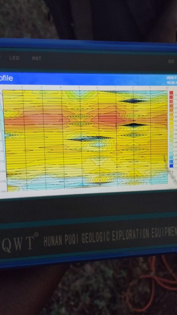
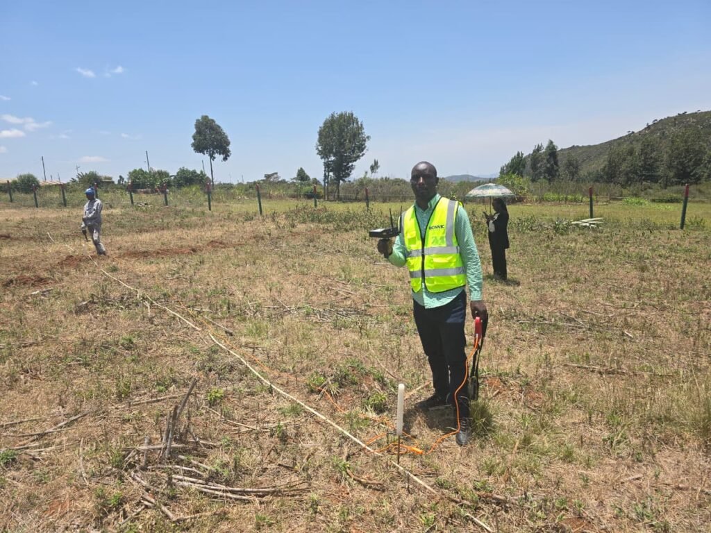
Method 3: Geophysical Surveys (Electrical Resistivity)
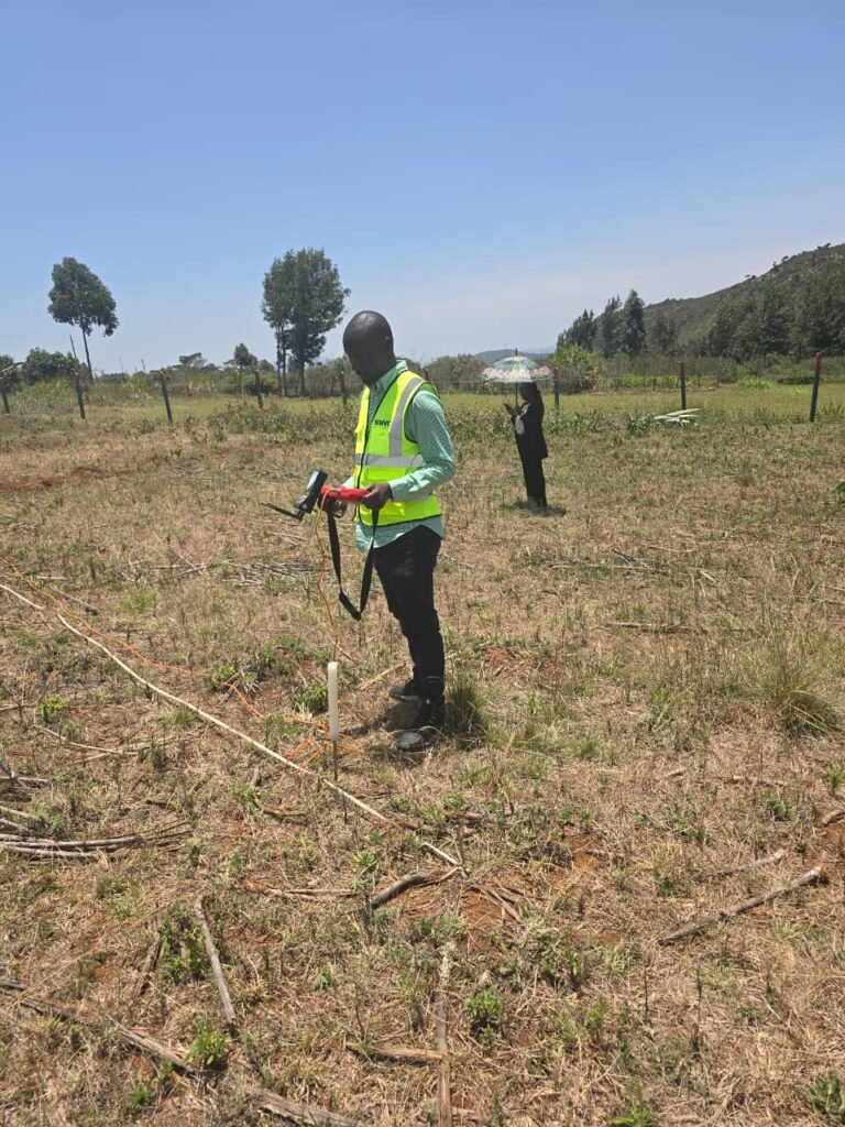
The Science Behind Electrical Resistivity
Geophysical surveys use electrical resistivity methods to “see” underground without drilling. Here’s how it works:
Basic Principle: Electrical current is sent into the ground through electrodes. Different materials conduct electricity differently:
- Fresh water: Higher electrical resistance (50-200 ohm-meters)
- Saline water: Lower electrical resistance (5-30 ohm-meters)
- Solid rock: Very high resistance (1,000+ ohm-meters)
- Clay/Saturated soil: Variable resistance depending on water content
What the Survey Reveals
1. Water-Bearing Zones Low-resistivity zones often indicate water-saturated formations.
2. Salinity Indicators Extremely low resistivity (below 20 ohm-meters) suggests:
- Highly saline water
- Clay layers
- Mineralized zones
3. Depth Profiling The survey creates a vertical profile showing:
- Depth to water table
- Thickness of water-bearing layers
- Potential yield zones
Limitations of Geophysical Surveys
While powerful, geophysical surveys have limitations:
- Cannot definitively confirm water quality (only indicators)
- Clay layers can mimic saline water signatures
- Require skilled interpretation
- Expensive for small residential projects (KES 80,000-150,000)
Best Practice: Combine geophysical surveys with geological assessment for highest accuracy.
Method 4: Topography, Hydrology & Environmental Clues
Reading the Landscape
Experienced geologists can assess salinity risk by observing environmental indicators:
Elevation and Drainage
- High ground with good drainage: Lower salinity risk
- Low-lying areas: Water accumulates and evaporates, concentrating salts
- Closed drainage basins: High salinity risk (e.g., Magadi area)
Proximity to Saline Water Bodies Distance from salt lakes, soda lakes, or the ocean significantly impacts salinity:
- 0-5 km from ocean: Very high seawater intrusion risk
- 5-15 km from ocean: Moderate to high risk depending on geology
- Near Lake Magadi, Elementaita, Bogoria: High alkaline/saline water risk
Soil Indicators
- White salt crusts on soil: Strong indicator of saline groundwater
- Poor vegetation despite adequate rainfall: May indicate saline soils
- Stunted crops or salt-tolerant plants: Suggests saline conditions
Historical Land Use
- Former lake beds or swamps often have saline water
- Areas with ancient marine deposits (sedimentary rocks)
Kenyan Examples
Coastal Kenya (Mombasa, Kilifi, Kwale): Properties within 10 kilometers of the ocean face significant seawater intrusion risk, especially if over-pumping occurs in the area.
Rift Valley (Naivasha, Nakuru, Baringo): Volcanic activity and geothermal influences create naturally alkaline and saline water in certain zones.
Eastern Kenya (Machakos, Makueni, Kitui): Sedimentary formations, especially in lower-lying areas, often contain moderately saline water.
Borehole Water Salinity Kenya: High-Risk Areas Map
Based on our extensive experience drilling across Kenya, here are regions where salinity is a significant concern:
VERY HIGH RISK AREAS
1. Coastal Region
- Counties: Mombasa, Kilifi, Kwale, Lamu (especially within 15 km of coastline)
- Primary Issue: Seawater intrusion
- TDS Levels: Often 2,000-10,000 mg/L in affected areas
- Recommendation: Mandatory hydrogeological survey, consider rainwater harvesting as supplement
2. Rift Valley Lakes Region
- Specific Areas: Near Lake Magadi, Lake Elementaita, Lake Bogoria, Lake Baringo
- Primary Issue: Volcanic/geothermal influence, alkaline conditions
- TDS Levels: Can exceed 5,000 mg/L
- Recommendation: Professional survey essential, expect treatment costs
MODERATE TO HIGH RISK AREAS
3. Eastern Kenya Lowlands
- Counties: Parts of Machakos, Makueni, Kitui, Tharaka Nithi
- Primary Issue: Sedimentary formations with trapped salts
- TDS Levels: 1,000-2,500 mg/L common
- Recommendation: Survey strongly advised, depth selection critical
4. Kajiado & Narok (Lower Zones)
- Specific Areas: Lower-lying areas, parts near Magadi
- Primary Issue: Geological formations, poor drainage
- TDS Levels: Variable, 800-2,500 mg/L
- Recommendation: Survey recommended, analyze nearby boreholes
5. Northern Kenya
- Counties: Parts of Samburu, Turkana, Marsabit
- Primary Issue: Arid conditions, mineralized groundwater
- TDS Levels: Often 1,500-4,000 mg/L
- Recommendation: Survey essential, consider alternative water sources
GENERALLY LOWER RISK AREAS
6. Central Highlands
- Counties: Kiambu, Murang’a, Nyeri, Kirinyaga (higher elevations)
- Water Quality: Generally good, TDS 200-600 mg/L
- Note: Still conduct surveys for optimal yield and depth
7. Western Kenya
- Counties: Kakamega, Bungoma, Vihiga, Kisumu (most areas)
- Water Quality: Generally acceptable
- Note: Iron content can be an issue, different from salinity
Important Note: These are generalizations. Localized geology can create variations within counties. Always conduct site-specific assessments.
The Reality Check: What Surveys Can and Cannot Tell You
What Pre-Drilling Assessment CAN Do:
✅ Identify high-risk vs. low-risk locations
✅ Recommend optimal drilling depth
✅ Provide probability estimates for water quality
✅ Suggest alternative sites if primary location is unsuitable
✅ Help you make informed decisions about proceeding
✅ Potentially save you from a complete financial loss
What Pre-Drilling Assessment CANNOT Do:
❌ Guarantee 100% certainty about water quality
❌ Predict exact TDS levels without drilling
❌ Account for all underground complexities
❌ Replace actual water testing after drilling
Why Uncertainty Exists
The underground is extraordinarily complex:
Fractured Rock Aquifers: Water flows through fractures and fissures. Two boreholes 500 meters apart might tap completely different fracture systems with different water chemistry.
Layered Aquifers: You might have fresh water at 80 meters sitting on top of saline water at 150 meters, or vice versa. The aquifer you intercept determines your water quality.
Local Variations: Faults, dykes, and geological discontinuities create localized variations that even the best survey might miss.
Human Factors: Over-pumping in nearby boreholes can draw saline water upward into previously fresh zones.
This is exactly why professional drilling companies like Bonvic Drilling always conduct water quality testing AFTER drilling, before handing over the project.
What Happens After Drilling: Water Quality Testing
Our Post-Drilling Protocol at Bonvic Drilling
Once we complete drilling and install the pump, we don’t just hand over the borehole and leave. Here’s our process:
Step 1: Development Pumping (24-48 hours) We pump the borehole continuously to clear drilling fluids, sediment, and stabilize the water yield.
Step 2: On-Site Testing Using portable meters, we immediately measure:
- TDS (Total Dissolved Solids)
- Electrical Conductivity (EC)
- pH levels
- Temperature
Step 3: Laboratory Analysis We collect water samples and send them to certified laboratories (e.g., Kenya Bureau of Standards, SGS, private certified labs) for comprehensive analysis:
- Complete mineral profile
- Bacterial contamination (coliforms, E. coli)
- Heavy metals (if applicable)
- Pesticides/nitrates (in agricultural areas)
Step 4: Results Interpretation We provide you with a detailed report explaining:
- What each parameter means
- Whether water meets WHO/KEBS drinking standards
- Required treatment (if any)
- Expected lifespan of pumps and pipes based on water chemistry
Step 5: Treatment Recommendations If water quality issues are discovered, we recommend appropriate solutions.
What If Your Water Is Salty? Solutions and Options
Discovering salty water doesn’t mean all is lost. Here are your options:
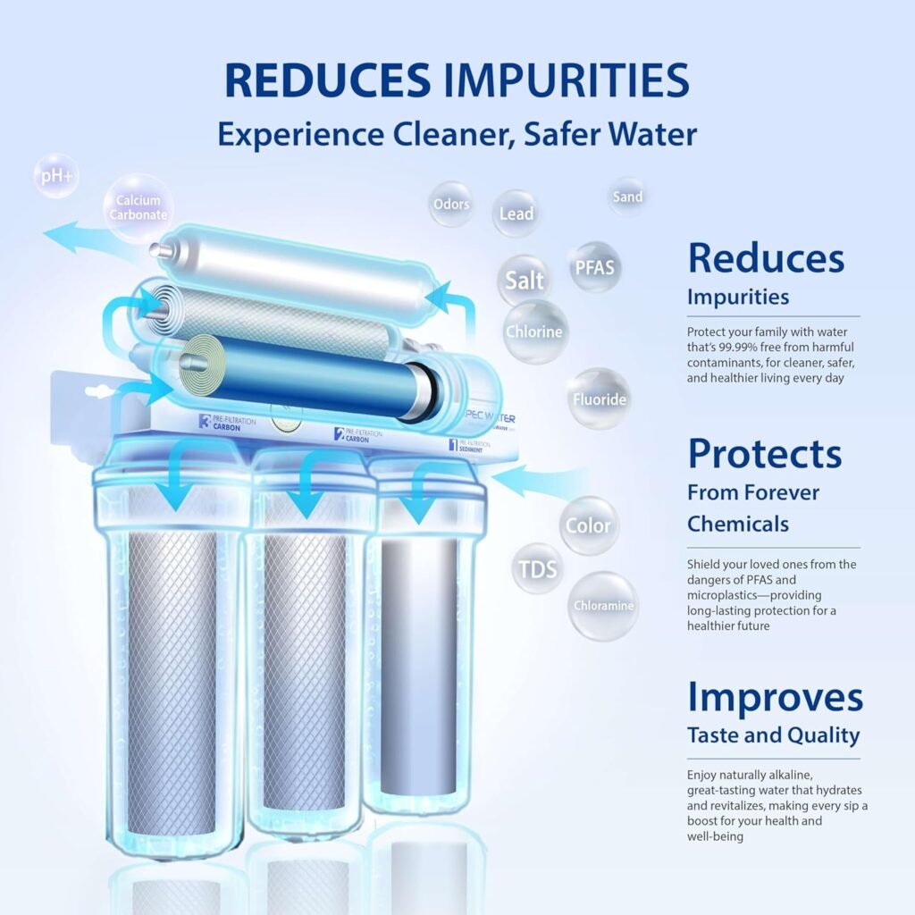
Option 1: Reverse Osmosis (RO) Treatment
How It Works: RO systems force water through semi-permeable membranes that remove dissolved salts, minerals, and contaminants.
Effectiveness: Can reduce TDS from 2,000-3,000 mg/L down to 100-300 mg/L, making water suitable for drinking and cooking.
Cost in Kenya:
- Domestic RO systems (50-100 liters/hour): KES 150,000-300,000
- Commercial RO systems (500-1,000 liters/hour): KES 400,000-800,000
- Large-scale systems: KES 1,000,000+
Considerations:
- Ongoing maintenance costs (filter replacements every 6-12 months)
- Electricity costs for pump operation
- Produces waste water (reject water ratio typically 1:3 or 1:4)
- Only treats water for specific uses, not entire borehole output
Best For: Residential use where limited quantities of drinking/cooking water are needed.
Option 2: Drilling at a Different Depth
Sometimes saline water exists at one depth while fresh water exists at another. Based on local data and geological understanding, we might recommend:
- Drilling deeper: If fresh water aquifers exist below saline zones
- Drilling shallower: If shallow aquifers have better quality (less common)
- Sealing off saline zones: Casing design to isolate poor-quality zones
Cost Implications: Additional drilling costs KES 1,500-3,000 per meter depending on geology.
Option 3: Alternative Location
If the survey and initial drilling indicate poor water quality across multiple depths, drilling at a different location on your property (or adjacent property with permission) might yield better results.
The hydrogeological survey typically identifies 2-3 potential sites ranked by probability of success.
Option 4: Blending with Alternative Sources
For agricultural or commercial use, slightly saline water can be blended with:
- Rainwater harvesting
- Municipal water supply
- Water from another borehole
This dilution can bring TDS levels to acceptable ranges for specific uses.
Option 5: Alternative Uses
Moderately saline water (1,500-2,500 mg/L TDS) might still be suitable for:
- Livestock (most animals tolerate moderate salinity)
- Irrigation of salt-tolerant crops
- Construction purposes
- Washing and cleaning (though may cause equipment wear)
Not ideal, but better than a complete loss.
The True Cost of Ignoring Pre-Drilling Assessment
Let’s examine two scenarios:
Scenario A: The Gambler (No Survey)
Costs:
- Drilling: KES 400,000
- Pump & installation: KES 120,000
- Total investment: KES 520,000
Outcome: Discovers TDS of 2,500 mg/L – water too salty for intended use
Additional costs to salvage project:
- RO treatment system: KES 250,000
- Annual maintenance: KES 30,000/year
- Total 5-year cost: KES 920,000
Stress level: Extremely high
Scenario B: The Planner (With Survey)
Costs:
- Hydrogeological survey: KES 50,000
- Drilling (at recommended depth/location): KES 400,000
- Pump & installation: KES 120,000
- Total investment: KES 570,000
Outcome: Survey identified optimal depth, water TDS: 450 mg/L – excellent quality
Additional costs:
- Minimal filtration: KES 15,000
- Total 5-year cost: KES 585,000
Stress level: Low, confident decision
Savings: KES 335,000 over 5 years, plus peace of mind
The numbers speak for themselves.
Why Choose Bonvic Drilling Company?
Our Commitment to Transparency
At Bonvic Drilling Company, we’ve built our reputation on one fundamental principle: honesty before profit.
We will NOT drill your borehole if our assessment indicates high risk of failure or poor water quality without first:
- Informing you of the risks
- Discussing alternatives
- Providing realistic expectations
- Ensuring you make an informed decision
Our Process:
1. Free Initial Consultation Contact us to discuss your project. We provide preliminary advice based on your location.
2. Site Visit & Assessment Our geologists visit your property to conduct initial assessments and discuss your water needs.
3. Hydrogeological Survey (Recommended) Comprehensive investigation with detailed report.
4. Transparent Quotation Clear pricing with no hidden costs. We explain exactly what you’re paying for.
5. Professional Drilling Modern equipment, experienced crews, adherence to safety standards.
6. Water Quality Testing Comprehensive testing before project handover.
7. After-Sales Support We remain available for consultation, maintenance, and any issues that arise.
Our Track Record:
✅ Successfully completed projects across Nairobi, Machakos, Kiambu, Kajiado, Nakuru, Laikipia, and other counties
✅ Over 15 years of experience in Kenyan geology
✅ Licensed and certified by relevant authorities
✅ Comprehensive insurance coverage
✅ Transparent pricing and contracts
✅ Satisfied clients willing to provide references
Frequently Asked Questions About Borehole Water Salinity Kenya
1. How accurate are hydrogeological surveys in predicting salinity?
Hydrogeological surveys combined with existing borehole data can predict salinity risk with 70-85% accuracy. However, complete certainty only comes after drilling and testing. The survey significantly reduces your risk and helps make informed decisions.
2. Is a hydrogeological survey legally required in Kenya?
While not always legally mandatory, the Water Act 2016 and WRA regulations require proper site assessment and permits before drilling. Many county governments now require hydrogeological reports as part of the drilling permit application, especially in sensitive areas.
3. How long does a hydrogeological survey take?
A standard survey takes 3-7 days:
- Day 1-2: Field investigation and data collection
- Day 3-5: Analysis, interpretation, and report writing
- Day 6-7: Report delivery and consultation
Geophysical surveys add another 2-3 days.
4. Can rainwater harvesting replace a borehole if salinity is a concern?
Rainwater harvesting is an excellent supplement but rarely a complete replacement in Kenya. Storage requirements for year-round supply are substantial. We recommend a hybrid approach: borehole for high-volume uses (washing, irrigation) and rainwater/RO-treated water for drinking/cooking.
5. What’s the difference between salty water and hard water?
Salty water = High TDS with sodium chloride, tastes salty, affects taste and usability
Hard water = High calcium and magnesium, causes scaling on pipes/appliances, doesn’t necessarily taste bad
Hard water is easier and cheaper to treat than highly saline water.
6. At what depth is water usually saline in Kenya?
There’s no universal answer – it varies by location:
- Coastal areas: Salinity risk increases closer to sea level
- Rift Valley: Shallow and intermediate depths can be saline due to volcanic influence
- Sedimentary basins: Deeper aquifers sometimes more saline than shallow ones
- Fractured rocks: Highly variable, depends on which fracture system you intersect
This is why site-specific surveys are essential.
7. Can boreholes become salty over time?
Yes, this can happen due to:
- Over-pumping drawing saline water upward
- Drought conditions concentrating salts
- Nearby over-extraction affecting the aquifer
- Seawater intrusion in coastal areas
- Contamination from surface sources
Regular water quality monitoring (annually) helps detect changes early.
8. Is there a simple field test for salinity?
Yes, relatively simple:
- TDS meters: Handheld devices cost KES 2,000-10,000, provide instant TDS readings
- Taste test: Not scientific but humans can detect salinity above ~1,000 mg/L
- Electrical conductivity meters: Similar to TDS meters, measure water’s ability to conduct electricity
However, comprehensive laboratory analysis is always recommended for drinking water.
9. What if my neighbor’s borehole has fresh water but mine is salty?
This happens! Underground water doesn’t flow uniformly. Possible reasons:
- Different drilling depths tapping different aquifers
- Geological variations (fault lines, fractures)
- Distance from contamination source
- Different casing designs affecting which water enters the borehole
This is frustrating but not uncommon. A hydrogeological survey helps identify optimal locations and depths specific to your property.
Take Action: Protect Your Borehole Investment Today
Don’t gamble with hundreds of thousands of shillings. Whether you’re planning a residential borehole, agricultural water supply, or commercial water system, start with the right information.
Understanding borehole water salinity Kenya patterns and conducting proper pre-drilling assessments is the smartest investment you can make.
Next Steps:
1. Schedule a Free Consultation Contact Bonvic Drilling Company for an initial discussion about your project. We’ll provide preliminary advice based on your location and water needs.
2. Request a Hydrogeological Survey Quote We’ll visit your site and provide a detailed quotation for comprehensive hydrogeological investigation.
3. Review and Decide With scientific data in hand, you can make an informed decision about proceeding with drilling.
4. Drill with Confidence If the survey is favorable, we proceed with professional drilling, knowing we’ve minimized your risks.
Contact Bonvic Drilling Company
📞 Phone/WhatsApp: 0720-545-191
📧 Email: hello@bonvicdrilling.com
🌐 Website: www.bonvicdrilling.com
Service Areas:
Nairobi County | Machakos County | Kiambu County | Kajiado County | Nakuru County | Laikipia County | Murang’a County | Kirinyaga County | And across Kenya
Conclusion: Knowledge is Your Best Protection Against Borehole Water Salinity Kenya
The underground doesn’t care about your budget, your timeline, or your dreams. It simply is what it is. But with proper investigation, scientific methods, and professional guidance, you can work with the geology rather than against it.
Hundreds of thousands of shillings are at stake. Understanding borehole water salinity Kenya risks and investing in a KES 50,000 survey might seem like an unnecessary expense when you’re eager to start drilling, but it’s the difference between a successful project and a financial disaster.
At Bonvic Drilling Company, we don’t just drill holes in the ground. We provide water solutions backed by science, experience, and integrity. Our expertise in assessing borehole water salinity Kenya across multiple counties has saved our clients millions in potential losses.
Your investment deserves protection. Your family deserves clean water. Your project deserves professional expertise.
Contact us today and let’s start your borehole project the right way – with confidence, knowledge, and realistic expectations.
Related Articles You Might Find Helpful:
- Borehole Flushing in Kenya
- The Hidden Dangers in Your Borehole Water
- PVC vs Steel Borehole Casing in Kenya
- How Far Apart Should Boreholes Be in Kenya?
Share This Article:
Found this guide helpful? Share it with friends, family, or colleagues planning borehole projects. Knowledge shared is money saved!
Disclaimer: This article provides general information about water salinity prediction and borehole drilling in Kenya. Every project is unique and requires site-specific assessment. The information provided should not replace professional hydrogeological investigation and consultation. Always work with licensed drilling professionals and comply with local regulations.