Every landowner asks the same question before calling a drilling company. How do you know if your land has water for a borehole? Guessing the answer is the single most expensive mistake you can make in borehole drilling.
This guide explains how a hydrogeological survey removes the guesswork. You will learn what the process involves and how to read the results before drilling starts.
Why Guessing Is a Costly Gamble
WITHOUT A SURVEY
30-40%
success rate when a drilling point is picked by guesswork
WITH A PROFESSIONAL SURVEY
70-90%
success rate when the point is chosen using resistivity data
Source: Raeli Hydro Engineering, geophysical siting study
Underground water does not sit in neat, predictable pools. It moves through fractured rock, sand layers, and weathered zones that vary across the same plot.
Research from Turkana County found that boreholes without a proper survey succeed only 30 to 40 percent of the time. A professional resistivity survey raises that success rate to 70 to 90 percent (Raeli Hydro Engineering).
Kenya’s groundwater situation adds to the pressure. Water levels under the Nairobi Aquifer System have fallen at a median rate of 6 metres per decade since 1950. Abstraction has increased tenfold since the mid-1970s (Hydrogeology Journal).
Aquifers that were productive a generation ago are not always reliable today. This makes site-specific data more important than ever.
For context on how tightly boreholes can interfere with each other, see our guide on borehole spacing requirements in Kenya.
How to Know If Your Land Has Water for a Borehole: The Survey Method
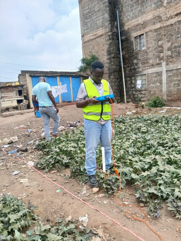
The reliable way to know if your land has water for a borehole is a hydrogeological survey. This is a scientific assessment of the ground beneath your land that happens before drilling begins. It combines geological mapping, electrical resistivity profiling, and sometimes seismic methods to build a picture of what lies underground.
In practice, a technician places electrodes across your plot and passes a small electrical current through the ground. Different materials, such as rock, clay, sand, and saturated zones, conduct electricity differently. Technicians use that data to identify likely water-bearing layers and estimate their depth.
The output is not a guarantee. It is a professional, evidence-based recommendation on where to drill and how deep to go. That is what separates an informed decision from a bet.
Signs That Suggest Your Land May Have Water
A survey is the only reliable way to know if your land has water for a borehole. A few surface indicators can still give you a rough first impression:
QUICK SELF-CHECK: WALK YOUR LAND AND LOOK FOR
Low-lying or valley terrain. Water naturally accumulates in depressions and drainage lines more than on hilltops.
Nearby productive boreholes. A strong borehole next door is a reasonable, though not conclusive, signal.
Certain vegetation patterns. Deep-rooted trees like fig and fever trees sometimes cluster where shallow groundwater is present.
Visible rock outcrops or fracture lines. Fractured basement rock can act as a channel for groundwater movement.
None of these signs replace a survey. They simply help a hydrogeologist decide where on your plot to focus testing.
What Happens During a Bonvic Site Survey
Our team starts with a desktop review of your area. We check any WRA groundwater data and geological records available for the region. We then visit your site to walk the plot and note the terrain, drainage, and nearby water points.
Next comes the electrical resistivity survey itself. We take readings at multiple points across the land. We process the data into a resistivity profile that shows likely rock and water-bearing layers at different depths.
You receive a written report recommending the best drilling point, an estimated depth range, and an honest yield assessment. This report becomes the basis for your WRA permit application and drilling plan.
THE SURVEY PROCESS, START TO FINISH
01
Desktop Review
Existing WRA and geological data for your area is checked first.
02
Site Visit
Our team walks the plot and notes terrain, drainage, and nearby water points.
03
Resistivity Survey
Electrical readings are taken across multiple points on your land.
04
Written Report
You get a recommended drilling point, depth range, and yield outlook.
A Realistic Example
Consider a two-acre plot in a peri-urban area outside Nairobi. The owner wanted to drill near the road for easy pump-house access, purely for convenience.
A resistivity survey across the plot showed the strongest water-bearing fracture zone was 40 metres away, near the boundary. Drilling at the convenient spot would likely have meant a shallower, less reliable borehole. The surveyed point offered a much better chance of a long-lasting supply.
This is the value a survey adds. It is rarely about whether water exists somewhere on your land. It is much more about finding the exact point where enough water exists.
After the Survey: What Comes Next
Once your survey report is in hand, three steps follow. You apply for a permit with the Water Resources Authority and drill at the recommended point.
Then you test pump the borehole to confirm its actual yield. Our guide to borehole test pumping in Kenya explains how we measure that yield.
Still deciding whether groundwater is the right investment for your property? Our complete guide to drilling a borehole in Kenya walks through the full process end to end.
Try our free calculator tools, including the Borehole Savings Calculator, to weigh the numbers before you commit.
Frequently Asked Questions
What is the fastest way to know if your land has water for a borehole?
A one-day resistivity survey is the fastest reliable method. Surface signs like low-lying terrain or a neighbour’s borehole can offer a rough first impression. Only a survey confirms an actual drilling point.
Can I skip the survey if my neighbour already has a good borehole?
Not safely. Groundwater conditions can change significantly within a short distance due to fracture zones, fault lines, and rock type. A neighbour’s success is a hint, not proof.
How long does a survey take?
A typical residential or commercial plot survey takes a single day on site, with the written report following shortly after.
Does a survey guarantee I will find water?
No survey method can offer a 100 percent guarantee, since underground conditions are never fully certain until drilling confirms them. What a professional survey does is dramatically shift the odds in your favour compared to drilling blind.
Not Sure If Your Land Has Water?
Get a professional hydrogeological survey from a WRA-licensed team with certified hydrogeologists, before you spend a shilling on drilling.
Not Sure If Your Land Has Water?
Get a professional hydrogeological survey from a WRA-licensed team with certified hydrogeologists, before you spend a shilling on drilling.