Quick answer: a geophysical survey measures the ground from the surface to find where water is most likely before you drill. In Kenya it is usually done by sending an electric current into the ground and reading the resistivity of each layer. The results go into the hydrogeological survey report that Water Resources Authority (WRA) needs before a motorised borehole can be drilled.
A good survey is the cheapest part of a borehole and the part that most often decides whether you hit water. Here is how it works, what the numbers in your report mean, and how to spot a weak report.
BLACK NOVEMBER 2026 OFFER
Hydrogeological survey KES 40,000. Drilling KES 6,500 per metre with PVC casing or KES 6,700 per metre with steel casing, for jobs booked by 30 November 2026.
WhatsApp for a quoteCall 0727 666444See the offer and estimate your total
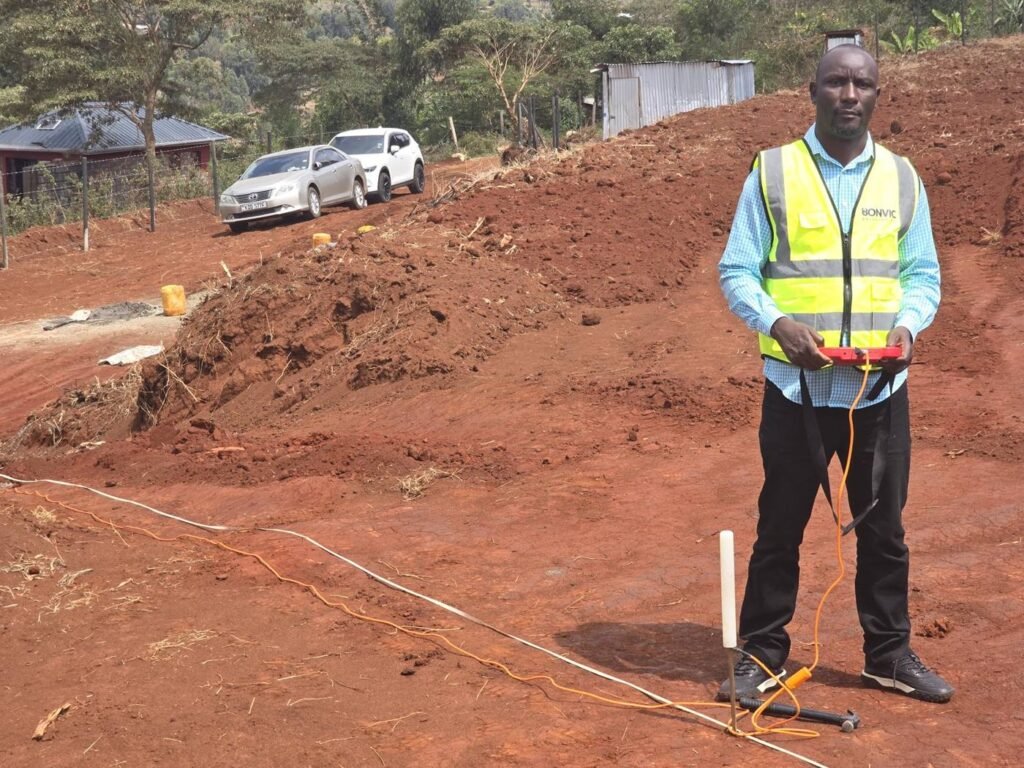
Geophysical vs Hydrogeological Survey
People use the two names for the same job, but they are not quite the same thing.
- The hydrogeological survey is the whole study: geology, nearby boreholes, water quality risks, the geophysical readings and the final recommendation.
- The geophysical survey is the field measurement inside it. It is the step that looks under the ground.
Our guide on what a hydrogeological survey is covers the full study. This article focuses on the geophysics.
The Main Methods Used in Kenya
| Method | What it does | Best for |
|---|---|---|
| VES (vertical electrical sounding) | Reads resistivity at one point as the electrodes move apart, building a picture of layers with depth | Depth and thickness of weathered and fractured zones at a chosen spot |
| ERT (electrical resistivity tomography) | Many electrodes along a line produce a 2D cross section of the ground | Seeing changes along a line: clay vs sand, fractures, faults, salty water |
| EM (electromagnetic) | Fast profiling of how well the ground conducts | Quickly finding fracture zones and thick weathered ground to then test with VES |
| Magnetic | Measures small changes in the earth’s magnetic field | Mapping faults and dykes that can carry water |
VES is the workhorse in Kenya because it is quick and affordable. Its weakness is that it assumes flat layers, so it can mislead where the rock changes from side to side (Kajiado groundwater report).
In a 2017 trial around Kajiado, ERT gave the best results, especially for seeing changes along the ground. At the Kakuma camp in Turkana, boreholes drilled on ERT targets tested at 29, 40 and 45 cubic metres an hour (CSEG Recorder).
A magnetic survey at Matuu in Machakos mapped a fault and fracture zone about 100 m deep, a clear groundwater target (UEAB study).
What the Numbers in Your Report Mean
Resistivity is how strongly a layer resists electric current, measured in ohm metres. Water, especially salty water, and clay let current through easily, so they read low. Dry soil and solid rock read high.
Resistivity reader
Survey reports list the resistivity of each layer in ohm metres. Slide to a value from your report to see what it usually means.
Ranges based on the US EPA electrical methods guide, Loke (2015) and the Kakuma groundwater survey in Turkana. Local geology changes the picture.
| Material | Typical resistivity (ohm-m) | Source |
|---|---|---|
| Clay | 1 to 20 | US EPA |
| Wet to moist sand | 20 to 200 | US EPA |
| Fresh groundwater | 10 to 100 | Loke, 2015 |
| Igneous rock (like phonolite and granite) | 100 to 1,000,000 | US EPA |
| Saline or clay rich zones (Kakuma) | Below 10 | Kakuma survey |
| Fractured or weathered bedrock (Kakuma) | Below 60 | Kakuma survey |
The ranges overlap, which is why the EPA warns that resistivity alone cannot identify a material. Different layer combinations can even produce the same curve, so a good hydrogeologist reads the numbers together with the local geology and nearby borehole records (British Geological Survey).
A Real Example: Reading a VES Curve
Here is how a 2013 WRMA survey at Kipkorgot in Moiben, Uasin Gishu, described the ground (WRMA survey report):
| Depth | Resistivity | Interpretation |
|---|---|---|
| 0 to 5 m | 800 ohm-m | Dry topsoil |
| 5 to 40 m | 20 to 50 ohm-m | Highly weathered phonolite |
| 40 to 100 m | 100 to 150 ohm-m | Weathered to fractured phonolite |
| 100 to 160 m | 200 ohm-m | Fractured phonolite |
| Below 160 m | 250 ohm-m | Grading to fresh rock |
In plain terms: the low readings near the top are moist, weathered rock, and the steady rise means you are moving toward solid rock. The report recommended drilling to a maximum of 200 m with an expected yield of 1 to 6 cubic metres an hour.
What a Good Survey Report Contains
Compare your report with this list. Real reports from Kipkorgot in 2013 and Koisabul in 2026 include all of these (Kipkorgot, Koisabul):
- GPS coordinates and altitude of the recommended drilling point.
- The geology and hydrogeology of the area.
- Data from nearby boreholes: depth, water struck level, rest level and yield.
- The geophysical method used, the readings and how they were interpreted.
- A recommended depth and borehole diameter.
- An expected yield range in cubic metres an hour.
- Water quality expectations, such as fluoride or salinity risks.
- Notes on supervision and the WRA steps that follow.
If your report has no readings, no nearby borehole data and only a single number for depth, ask questions before you pay for drilling. Our guide on how to read a hydrogeological survey report walks through a full report.
Why the Survey Matters: Kenya's Success Rates
A 2004 JICA study of existing boreholes found success rates (at least 1 cubic metre an hour) of 86.3% in Machakos, 68.9% in Kitui, 66.1% in Makueni and 61.6% in Mwingi (JICA). It counted boreholes with too much fluoride as failures too.
A Dutch funded project linked Kenya's low drilling success to geophysics that was poorly applied or misread (Aqua for All). And in the 2022/23 financial year, the Auditor General flagged Sh47.2 million spent on boreholes that produced no water, noting it could not confirm surveys had been done (Eastleigh Voice).
The lesson is simple. Skipping or rushing the survey is the most expensive way to save money.
The Law: Surveys and Permits
Kenya's water regulations require a hydrogeological survey report with the application for any borehole that will be fitted with a motorised pump. Technical reports must be prepared by a licensed water sector professional, and in practice they are signed by a registered hydrogeologist (Water Resources Regulations, 2021).
After drilling, a completion record goes to WRA within 28 days, and the water use permit lasts five years before renewal. We handle the paperwork for about KES 85,000. See borehole permits in Kenya for every step.
How a Bonvic Survey Works
- Send your location. WhatsApp us a pin, the plot size and what the water is for.
- Desk study. We check the geology and records of nearby boreholes.
- Field survey. Our hydrogeologist runs the geophysical readings on site, usually in a day.
- Report. You get the drilling point, recommended depth, expected yield range and water quality risks in writing.
- Permits and drilling. The report goes into your WRA file, and the rig follows.
Want a rough cost before the survey? Try the borehole cost guide or the Black November estimator.
Planning a borehole in your area?
WhatsApp us your location (village and sub county). We will tell you the expected depth and a cost range for your area. Drilling across Kenya since 2010.
WhatsApp 0727 666 444Call 0797 000 555Related: see exactly what you pay before drilling in our hydrogeological survey cost guide, with a budget calculator.
Frequently Asked Questions
What is a geophysical survey for a borehole?
It is the part of a hydrogeological survey that measures the ground from the surface, usually by passing an electric current through it. The readings show where wet, weathered or fractured layers are likely, so the hydrogeologist can pick the drilling point and expected depth.
How much does a borehole survey cost in Kenya?
Bonvic charges KES 50,000 for a hydrogeological survey with a geophysical survey and report. During Black November 2026 it is KES 40,000 for jobs booked by 30 November.
How long does a geophysical survey take?
Fieldwork for a single site usually takes one to two days, and the report follows soon after. Large programmes with several methods take longer.
Does a geophysical survey guarantee water?
No. It greatly improves the odds, but no survey can promise water or a set yield. A good report gives a recommended depth, an expected yield range and the water quality risks.
Do I need a survey report to get a borehole permit?
Yes. Kenya's water regulations require a hydrogeological survey report with the application for any borehole that will have a motorised pump.
What is VES in a borehole survey?
VES means vertical electrical sounding. Electrodes are moved further apart around one point to read how resistivity changes with depth, which shows the layers under that spot.